| Baccalieu Trail Heritage Corporation |

|
|
|||
New Discoveries
| Date: Nov. 6th '13 | |
| Time: | |
| Title: Excavating Structure 9 at the Cupids Cove Plantation, Oct 25, 2013. | |
 | |
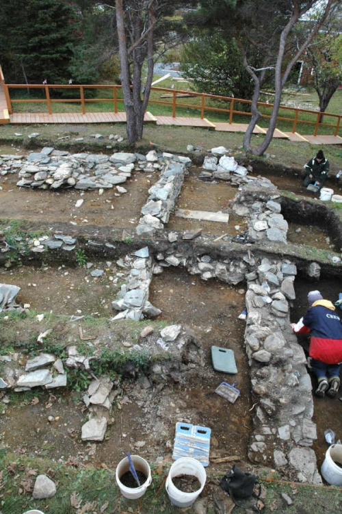
| Entry: November 6, 2013 Excavations at the Cupids Cove Plantation PHS finished this year on October 25. During 2013, much of our work focused on a stone feature located about 5m east of the Spracklin House, near the entrance to the site. Until the summer of 2010 a clapboard garage had stood in this spot. The garage was literally falling down and, in the course of preparing the site for the 400 anniversary celebrations, it was removed. Beneath its wooden floor we noticed a concentration of flat stones. We were unable to investigate further at the time and the area was covered with a layer of topsoil and seeded. This stone feature stands on the low ground at the edge of the bank that rises south and east to the terrace where the main part of the site is located. The outer defensive wall and gun platform uncovered between 2009 and 2011 are located on this terrace about 20m farther south (see entries for Oct. 31 & Nov. 18, 2011 on Page 2). Once the garage had been removed and the area cleaned up, we could see two ridges on the edge of the bank. A 5m long ridge runs from west to east along the southern edge of the bank and is adjoined, at its eastern end, by a second ridge which extends north from it at a right angle for 7m. When probed with a chaining pin, these ridges appeared to consist mainly of solid rock beneath a 20cm overburden of soil. In 2012 we dug one test pit south of the east-west ridge and another east of the north-south ridge. Both produced 17th century artifacts. In 2013 we returned to this area to have a closer look. At first we thought the ridges might mark the location of stone walls but we soon discovered that they were formed from rubble deposited in the 17th century. The concentration of stones just north and west of these ridges turned out to be part of a feature, which we have designated Structure 9. Structure 9 is about 4.5m (14 ¾ ft) wide, from east to west. That portion of it exposed to date runs north from the southern edge of the bank for 6.28m (20 ½ ft) although it may well extend beyond that. The remains of stone walls run along the eastern, southern and western sides of the structure and stones have been laid down inside the space defined by these walls to create a platform clearly designed to raise this area above what was originally the high water mark. Although today Structure 9 lies 30m south of the Salt Water Pond on the south side of Cupids harbour, this is a result of infilling over the past two centuries. In the 17th century the structure would have stood right on the water’s edge. Even now, when the tide is unusually high, salt water sometimes flows in through the culverts and floods the area to the west of Structure 9. It would appear that Structure 9 is part of some sort of harbour-side facility, possibly a dock or wharf. It also seems clear that the structure dates to the 17th century. Aside from the debris left over from the collapse of the garage and a layer of fill deposited immediately west of it in the 19th century, all the artifacts found in association with Structure 9 are of 17th century origin (see the images below). Of course, wharves and docking facilities would have been essential to the proper operation of a colony so closely connected to the sea and it makes sense that we would find the remains of such structures on the original shoreline. In the course of uncovering the east wall of Structure 9, we also extended the excavation into the bank that rises to the east just beyond it and were surprised to find that, instead of being natural, at least a portion is made up of large pieces of rubble that were deposited in the 17th century. At this point we cannot say exactly how much of the bank is rubble. Nor do we know if the rubble is collapse from Structure 9 or the remains of another building farther to the east. In 2014 we will be uncovering more of Structure 9 and extending the excavation farther east into the bank. | |
| Date: Nov. 18th '11 | |
| Time: | |
| Title: More Defensive Wall Uncovered at Cupids | |
 | |
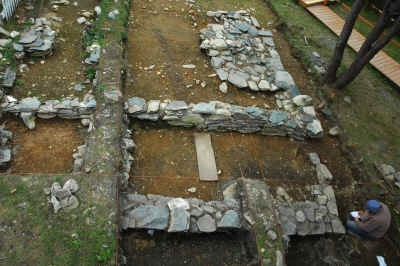
| Entry: November 18 , 2011, 10:15 am More of the Defensive Wall Uncovered at Cupids Cove Plantation Provincial Historic Site Excavations at the Cupids site ended this year on November 4. By the time we had finished digging, we had uncovered a 26 ft ( 7.9m) long section of the newly-discovered defensive wall located north of the gun battery. The wall is 2ft 2 inches (0.66m) wide at its base and, although we won’t know for sure until next season, appears to extend farther east beyond our current excavation. This makes a total of three stone defensive walls uncovered at the site to date. The first wall, located roughly 43ft (13.1m) to the south of this one, and running parallel to it, was first discovered in 2003 and mostly excavated in 2008. Measuring 2ft 8 inches (0.81m) thick, this first wall is the most substantial of the three and appears to be the north wall of the enclosure erected by the colonists in 1610. Roughly 21ft (6.5m) north of this first wall, and closer to the harbour, is the 13 ½ ft (4.11m) long stone gun platform first identified last year. Two feet (0.60m) north of the platform and attached to it by a short north-south wall is a second wall, 16 inches (0.41m) thick, running from east to west, parallel with the other two. Our newly-discovered wall is 5ft (1.52m ) north of this second wall. As we have previously speculated (see entry for Oct 11, 2010 below)), it seems most likely that these defense works are part of the major fortification effort undertaken by the colonists under the direction of John Guy in the summer of 1612 in an attempt to defend the colony from the threat posed by piracy. Although excavations ended two weeks ago, we hope to have the section of this third wall that was uncovered this year mapped before Christmas. Hopefully the weather will cooperate. Photo Above: Looking west along the second and third defensive walls. The stone gun platform can be seen in the distance to the left. | |
| Date: Oct. 31st '11 | |
| Time: | |
| Title: New Discovery at Cupids Site | |
 | |
| Entry: October 31 , 2011, 4:00pm New Discoveries at the Gun Battery, Cupids Excavations at Cupids this year began in late May and will continue until November 4. One of the areas we’ve been concentrating on this season is the gun battery located in the northwest corner of the site (see entries for Nov 19, 2009 and Oct 11, 2010 below). Excavations here in 2009 and 2010 revealed the remains of a stone gun platform running from north to south and attached to a stone defensive wall running from west to east just north of the platform and roughly parallel to the south side of the harbour. When the gun platform was first uncovered, it appeared to measure 8 ½ ft x 6 ½ ft (2.6m x 1.98m). However, when we dug deeper down this season, we found that the platform originally extended south for an additional 5ft (1.52m) and was actually 13 ½ ft (4.11m) long . Much of the southernmost section of the platform had been dismantled at some time in the past but enough of it remained to allow us to determine its original dimensions. North of the defensive wall we uncovered a deposit of rubble that seems to have been laid down in the 19th century to level off this area. This year we extended the excavation north into this rubble deposit to better expose the north face of the wall, properly record it, and draw a profile. Much to our surprise, roughly 5ft (1.5 m) north of this wall, at the edge of the rubble deposit, we uncovered a second stone wall. When we first uncovered it, we thought that it might be the remains of a crude wall erected in the 19th century to hold back the rubble. However, as more of it was exposed, we realized that we had uncovered the remains of a second, well-constructed wall dating to the 17th century. This second wall runs parallel to the first and appears originally to have been attached to the western end of it by a short north-south wall the traces of which can still be seen. We are currently extending the excavation east to uncover more of this wall. | |
| Date: Nov. 9th '10 | |
| Time: | |
| Title: Another Grave Found at Cupids | |
 | |
| Entry: November 9 , 2010, 4:35pm Another Grave uncovered at the Cupids Cove Plantation Site Most of our work in the cemetery at the Cupids Cove Plantation this year has focused on recording what has already been uncovered. First the cemetery was photographed and mapped with the gravestones in place. Then, because many of the stones had fallen over and were obscuring the grave pits, they were removed and the cemetery was photographed and mapped a second time to record the location and dimensions of each pit. The only stone that wasn’t removed is a late-18th -century, grey-Lias stone, from Dorset or Somerset, that, at some point in the past, fell on another grave marker and shattered into hundreds of pieces. This stone will remain where it fell, at least for now. Back in June, the massive back-dirt pile that had prevented us from expanding the cemetery excavations to the north was remove and this past Friday, November 5, we decided to open a 1 ½ m x 2m unit in this area to see if we could find any more graves. It wasn’t long before the distinctive outline of a grave pit began to emerge 15 inches (40cm) north of and parallel to the grave marked by the grey-Lias stone (Burial 3). Initially, we only exposed the eastern half of the pit but in the afternoon we expanded the excavation west for 1 ½ metres and uncovered the rest of it. Measuring 6ft 3in (190cm) long and 19in (48cm) wide at its widest point, this is one of the larger grave pits uncover to date and suggests that more graves may await discovery in this area. No marker stones were found in association with this new grave but a displaced marker stone located a short distance to the west originally may have marked the head. To date ten grave pits have been uncovered in the cemetery at Cupids. Of these, four, ranging in length from 47 ½ inches (1.21 m) to just 27 inches (68.5cm), are almost certainly the graves of children. Another, measuring only 4ft 4 inches (1.32 m), must be either the grave of an adolescent or an unusually short adult. At this point, we cannot say exactly how old all of these graves are. The grey-Lias stone clearly dates to the late 18th century and another, carved from Portland Stone, appears to date to the early 18th century. However, some of the other graves may well be 17th century. Indeed, given it’s location, just a short distance south of the 1610 enclosure, it seems highly likely that this is the cemetery first established by the colonists in that year. If it is, it must have continued to be used for roughly 180 years and the high proportion of children’s graves clearly indicates the presence of families at the site. So far none of the graves have been excavated. Instead we are uncovering and recording the location of the grave pits and marker stones. Over the next few weeks the grave pits will be covered in sand to protect and better define them and the marker stones will be put back in place. Graves that were unmarked will be marked with white crosses and the cemetery will be landscaped. In 2011 we will extend the excavation to the north in an attempt to determine the total number of graves in the cemetery. (For more on the Cupids Cove Plantation Cemetery see the entries for Dec. 11, 2007 & Aug. 26, 2008 below) Photo Above: Uncovering another grave pit at Cupids, November 5, 2010. The shattered grey-Lias headstone and the grave pit (Grave3) associated with it can be seen on the left. | |
| Date: Oct. 11th '10 | |
| Time: | |
| Title: Gun Platform Discovered at Cupid's | |
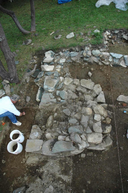 | |
| Entry: October 11, 2010, 12:30pm Early 17th Century Gun Platform found at Cupids Excavations conducted since late August on the stone structure (Structure 7) located north of the northern defensive wall at Cupids have confirmed that it is a gun battery (see the entry for November 19, 2009 below). Digging on the western side of this structure has uncovered a small, stone gun platform built to mount a cannon. The main part of Structure 7 uncovered to date consists of a stone wall located about 38ft north of the main defensive wall and running parallel to it (see entry for October 20, 2008). To date 21ft (6.4m) of this wall has been exposed but it extends farther east for an as-yet-unknown distance. The gun platform, which measures 8½ ft x 6½ ft (2.6m x 1.98m), is connected to this wall by a 2 ft (61cm) long wall that extends south from the western end of the main wall. The land drops away to the west and north of the platform providing a commanding view of the river valley and harbour. While the artifacts found in association with Structure 7 are not as plentiful as those found inside the enclosure, those that have been recovered indicate that it was probably erected early in the 17th century. These include fragments of ceramics such as Raeren Stoneware (circa 1580-1620) and Werra Slipware (circa 1590-1630) along with a number of clay pipe bowl fragments dating to the early decades of the 17th century. From John Guy's second letter, written on May 16, 1611, we know that when they arrived at Cupids the colonists erected "three pieces of Ordnance ...to command the harbours upon a platform made of greate posts and rails and great Poles sixteen foot long set upright around about with two flankers to secure the quarters." We also know that the threat posed by piracy in 1612 led the colonists to upgrading the defenses of the colony. In a letter dated September 3, 1612 John Slany, the Treasure for the colony, reported that when these defenses are finished the colony "will be impregnable ...against the next yeare if the pirotts return." It seems likely that Structure 7 and the main stone defensive wall to the south of it were both part of this 1612 fortification effort. Excavations at Cupids this year will continue until 5 November. During the time remaining we will uncover more of Structure 7 and do some more digging in the cemetery (see August 26, 2008 below) in an effort to locate more burials. Photo Above: The gun platform at Cupids when it was first uncovered on September 27, 2010 | |