| Baccalieu Trail Heritage Corporation |

|
|
|||
New Discoveries
| Date: May. 1st '06 | |
| Time: | |
| Title: Burnt Portuguese Ceramics from Cupids | |
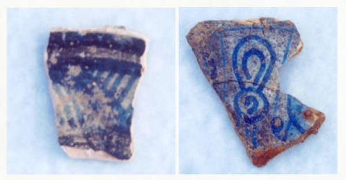 | |
| Entry: Burnt Portuguese Tin-Glazed Earthenware from Cupids Excavations near the north wall of the enclosure at Cupids over the past few years have uncovered hundreds of fragments of burnt ceramic. Much of it was found either up against or just south of the stone wall that once formed part of the enclosure and obviously had been deposited there after that wall was built (see map and photo below). These fragments include a variety of wares but among the most common are shards of burnt German Bellarmine (or Bartmann) bottles, Iberian (Spanish or Portuguese) olive jars and Portuguese tin-glazed earthenware (or maiolica). Clearly this area was used as a midden (or dump) and it would appear that these shards are from vessels that once belonged to the people who lived in the dwelling house. When broken they were probably thrown into the fireplace and later dumped next to the wall with the ashes from the fire. A thorough analysis of this material has yet to be conducted but several fragments have been identified by Eleanor Stoddart. For those of you who may not know, Eleanor wrote her MA thesis on seventeenth-century tin-glazed earthenware from Ferryland. Eleanor has identified one maiolica fragment as dating to around 1650 and most likely part of a plate (above left). Another is from a Portuguese maiolica plate that dates to between about 1625 and 1650 (above right). According to Eleanor this plate would have been “probably 20 cm in diameter” and “decorated with a stylised Chinese Wan-Li pattern, also referred to as a ‘Europeanized Wan-li pattern’ ”. For those of you who have a copy, an image of an almost complete plate, very similar to the one from Cupids, can be seen on page 219 of Peter Pope’s Fish Into Wine. Analysis of all the material from this midden will provide us with important information not only on the kinds of ceramics used by the people who lived in the dwelling house but also on other aspects of life in seventeenth-century Cupids such as trading patterns and social status. These burnt shards are already shedding light on the sequence of construction at the site. The cobblestones and flagstones just south of the enclosure wall were laid out on top of the midden in which these shards were found - clear evidence that these stones were placed there sometime after circa 1650. Although Portuguese maiolica is rare on 17th century sites in England it is more common on 17th century English sites in New England and Newfoundland. This probably reflects the close trade links between these colonies and Portugal. Fragments of Portuguese maiolica have been found elsewhere on the Cupids site. For example, part of a Portuguese footed cup dating to sometime between 1620 and 1630 (and also identified by Eleanor) was found inside the storehouse (See Artifacts and Features). | |
| Date: Mar. 10th '06 | |
| Time: | |
| Title: The 1610 Enclosure | |
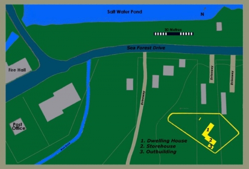 | |
| Entry: Excavations at Cupids Uncover Evidence of the 1610 Enclosure In a letter dated May 16, 1611, John Guy reported that the colonists at Cupers Cove had built “a Storehouse to hold our provisions and a dwelling house for our habitation, which was finished about the first of December [1610], with a square inclosure of one hundred and twenty foot long and ninety foot broad compassing these two houses...”. By the spring of 1613, at least 16 structures (including a workhouse, a brew house, a saw mill and a fort) were standing at Cupers Cove and, while we now know that other buildings also once stood inside the enclosure, the only two specifically mentioned by Guy are the dwelling house and storehouse. We discovered the dwelling house in 1995 and the adjoining storehouse in 1997. Since then both of these buildings and a number of related features have been excavated. In 2002 we uncovered a 20 inch (51 cm) wide builders’ trench running along the northern boundary of the site and in 2003 we found the base of a two foot (61 cm) wide stone wall extending west just beyond this trench (see photo below). That same year we found two 10 inch (25 cm) wide postholes eighteen feet (5.5 m) east of the storehouse and last year (2005) we uncovered another two 10 inch wide postholes eighteen feet south of the dwelling house. The two posts south of the dwelling house are six feet (1.82 m) apart at the centres and form a line that runs parallel to the south end of the dwelling. The two located east of the storehouse are eight feet (2.43 m) apart at the centres and form a line running northeast at a 105 degree angle to the line formed by the other two. There can be little doubt that the stone wall and trench running along the northern boundary of the site are part of the enclosure erected in 1610 and, while two posts do not necessarily make a wall, the size, location and orientation of the postholes found so far suggest that they were probably part of the enclosure as well. During the 2006 field season we will be conducting further excavations to see if we can find evidence of more posts. The outline on the map above was produced by extending the lines established by these features and combining this with data recovered during excavations and test pitting. The map shows the probable outline of the enclosure (in yellow) and how it relates to the buildings already excavated (also in yellow), the buildings currently standing in the area (in grey), and the surrounding topography. The West Brook is shown following the course it would have followed before it was diverted a number of years ago. Much of the land north of Sea Forest Drive is man-made. In 1610, and for many years thereafter, the salt water would have extended south at least as far as the present day road. While further excavations may result in some changes, the outline of the enclosure shown here should be fairly accurate and provides us with important information on which to base further excavations and research. If these features are part of the original enclosure then they also provide important clues has to how the enclosure was built. Clearly part of the north wall, facing the harbour, was of stone construction while the substantial trench extending east from the stone wall suggests that this portion of the enclosure (also facing the harbour) may have been built by placing posts side by side in the ground similar to the way nineteenth-century American forts are often depicted. In the letter quoted above Guy also talks about mounting guns “upon a platforme made of great posts and rails and great Poles sixteene foot long set upright around about” but this appears to have been separate from the enclosure. The size and spacing of the posts to the east and south of the dwelling house and storehouse indicate that in this area the enclosure wall was probably of post and rail construction. This technique was often used in building seventeenth-century wooden defence works. Horizontal rails ran between the main supporting posts and vertical planks, or pales, were fastened to the rails to create a continuous, solid wall. Often the pales were sharpened at the top to further deter unwanted visitors. A distance of six to eight feet between the supporting posts would have been fairly common. A description of this type of fortification from 1622 states that the posts should be seven feet apart and that the pales should be seven feet high. The pales used at Cupers Cove, and the wall of which they were a part, were probably about the same height. Of course, the enclosure is only one part of a larger site. In addition to the structures already mentioned Guy says that by May 1611 the colonists had erected two saw pits, a workhouse and a forge and that they had almost finished “ a farre greater and fairer house then that which as yet we dwell in”. As mentioned above, at least sixteen buildings were standing at Cupers Cove by the spring of 1613 and more were almost certainly added after that. Exactly where all of these building stood is as yet unknown but we do know that the site extends west and northwest beyond the walls of the enclosure. | |
| Date: Feb. 10th '06 | |
| Time: | |
| Title: Base of Stone Wall at Cupids | |
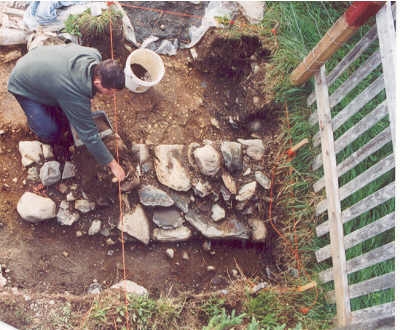 | |
| Entry: Uncovering the Base of the Stone Wall on the North Side of the Enclosure at Cupids. | |
| Date: Oct. 30th '05 | |
| Time: | |
| Title: Silver One Real from New Perlican | |
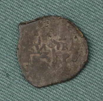 | |
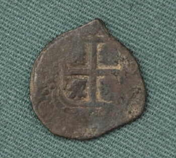
| Entry: October 30, 2005 Excavations End at New Perlican for Another Season/Spanish American Silver Coin Found Excavations at New Perlican have finished for another season. This past Friday (October 28) we began to backfill the site and we will be returning tomorrow (October 31) to finish backfilling and to secure the site for the winter. Our work this season has been very rewarding with both Area C and Area D producing a wide range of material. One of the more significant artifacts recovered from the seventeenth-century pit in Area C was a Spanish American silver one real coin manufactured in Potosi in what is now Bolivia. The shield of Castile and Leon in Spain can be seen on the obverse side of the coin with the Castilian Loin clearly visible in the lower left hand quarter (see image above). Part of the Latin motto “PLVS VLTRA” can be seen on the reverse side of the coin (see image below). This motto was adopted by the Spanish monarchy in the sixteenth century and refers to the Spanish colonies in the New World. The ‘P’ below the ‘R’ is the mark of the Potosi mint. Photos of the coin along with its weight and measurements were sent to Paul Berry, Curator of the Canadian Currency Museum at the Bank of Canada. According to Paul, although coins of this type were made from 1652 until the late 1760s, this coin probably dates to the 1650s. What appears to be a letter ‘E’ can be seen above the ‘R’ on the reverse. This is probably the mark of Antonio de Ergueta the assayer who worked at Potosi between 1651 and 1678. The numeral ‘3' can also be seen below the ‘V’ on the reverse of the coin where the date would normal be located. This suggests that the date of the coin may be 1653. Because the Spanish American silver mines were so productive during this period, Spanish American coins were common in the English colonies in the seventeenth century. When we first found the coin we thought that it had been clipped but, according to Paul, the unusual shape is typical of Spanish American “cob” coins from this period. | |
| Date: Oct. 30th '05 | |
| Time: | |
| Title: Silver One Real (Reverse) | |
 | |
| Entry: | |