| Baccalieu Trail Heritage Corporation |

|
|
|||
New Discoveries
| Date: Dec. 11th '07 | |
| Time: | |
| Title: Headstone Found at Cupids Site | |
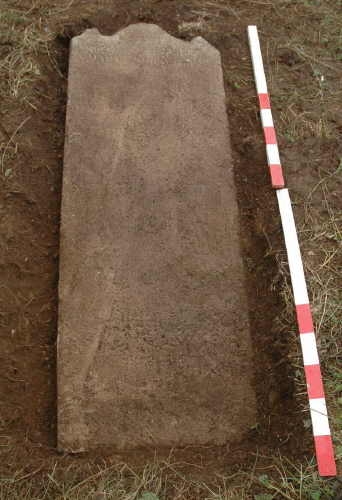 | |
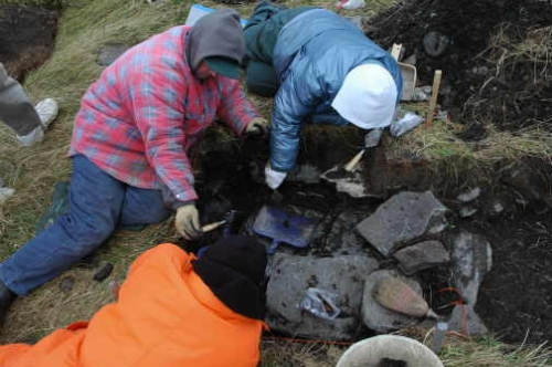
| Entry: December 11, 2007. 4:40 p.m. Headstone Uncovered at the Cupids Site November 15 was a beautiful autumn day and we decided to take advantage of the good weather by getting some last minute work done at the site in Cupids. A few weeks earlier some of the crew had raked up the leaves and laid them in a pile about fifty feet (15.24m) south of the site. We decided to move these leaves over next to the back dirt pile and shovel some earth over them. Some wood was piled in the area where we wanted to stack the leaves. We removed the wood and found beneath it an old, wooden gate half buried in the ground. One of the crew members, Linda Saunders, grabbed the gate and began to haul it up. With it came about four inches (10 cm) of sod and top soil beneath which was the uppermost part of a headstone. We spent several hours uncovering the stone and when it was fully exposed it turned out to be six feet (1.83m) long and 27 ½ inches (69.8cm) wide. It is carved from a light grey sandstone and at least two lines of a well-weathered inscription can be seen although it has yet to be deciphered. According to Dr. Jerry Pocius at Memorial University’s Centre for Material Culture Studies, the stone likely dates from the early 18th century and was probably carved in Dorset, England. Although stones of a similar type were made in the late 17th century, they were usually smaller than the one found at Cupids. The discovery of this stone roughly 50 feet south of the 1610 enclosure raises some interesting questions. The stone almost certainly marks the location of a grave and where there is one grave there may well be more. We know that a number of colonists died during the early years of the colony and no doubt there were other deaths for which we have no record. Could this be the location of the cemetery used by the colonists in the 17th century? It is certainly possible that a 17th-century cemetery could have continued to be used until the early years of the 18th century. On the other hand, if this turns out to be a solitary grave, one has to wonder why just one person would have been buried so close to the plantation site. Could this be someone who had a close association with the colony? Certainly whoever was buried here must have been fairly well to do: it is unlikely that many people in early 18th-century Newfoundland could afford to have a large gravestone carved in England and shipped across the Atlantic. Next season we will open up more of this area to see if we can uncover any other evidence of burials. | |
| Date: Oct. 24th '07 | |
| Time: | |
| Title: Excavating Structure 2 at Cupids | |
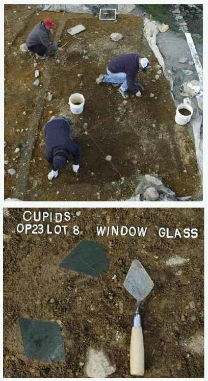 | |
| Entry: October 24, 2007. 8:25 p.m. Excavating Structure 2 at Cupids Structure 2 is a small building (15 ft. x 9 ft.) located three feet (0.91m) south of the storehouse at Cupids. It was first discovered in 1999 but only partially excavated at that time. Now the crew has returned to Structure 2 to complete the excavation. This building appears to have been erected during the early days of the colony and may have been destroyed in the fire which also destroyed the dwelling house and storehouse in the 1660s. Traces of the north and south sills of the building can still be seen in the ground. Samples of this decayed wood have been taken and will be sent to the Biology Department at Memorial University for identification. Although small, Structure 2 obviously had glazed windows: numerous fragments of light-green, seventeenth-century window glass have been recovered from the building. The two examples shown above were found in the northwest corner of Structure 2 on October 23. The one at the bottom, to the left of the trowel, is a typical seventeenth-century, diamond-shaped window pane or ‘quarry’. A number of these quarries would have been fitted together with grooved lead strips, sometimes referred to as ‘cames’, anchored to iron frames, and fitted into wooden casements to form a window. Above the first quarry is a less common five-sided example that may have been located on the edge of the casement. Large numbers of wrought iron nails are also being found that must have been used in the construction of the building. Other artifacts being recovered include shards from various types of coarse-earthenware vessels and fragments of both case bottles and shaft and globe bottles. Several trade beads have also been recovered. Photos above: Top. Looking west across Structure 2, October 2007. Note the remains of the decayed wooden sills on the left and lower right of the photo; Bottom. Two light-green glass window quarries found in the northwest corner of Structure 2 on October 23, 2007. | |
| Date: Jul. 6th '07 | |
| Time: | |
| Title: Four Recent Indian Hearths on Dildo Island | |
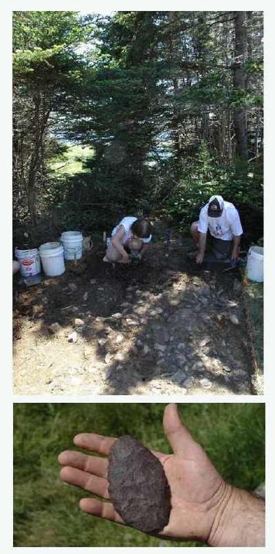 | |
| Entry: Dildo Island, July 6, 2007 Four More Recent Indian Fireplaces Have Been Found on Dildo Island Our four weeks of testing on Dildo Island have proven very successful. After digging eight 2m x 2m excavation units and approximately 50 40cm x 40cm test pits, we have uncovered four more Recent Indian fireplaces. Three of these are located on the terrace near the edge of the slope leading down to Barry’s Cove and approximately 30 metres south of the Recent Indian linear hearth that we excavated in 2004. The forth is situated on the same terrace about 32 metres northeast of the other three. Fire-cracked rock and lithic material found in two other test pits suggest that there are at least another two hearths in this area. The first three fireplaces appear to be roughly contemporary with the linear hearth and, therefore, probably date to around AD 800 (roughly 1200 years ago). However, the forth, while still prehistoric, appears to be more recent. The shaft of a wrought iron nail found about seven metres east of the first three hearths and beneath a scattering of fire-cracked rock and blue chert flakes suggests that there may also be a Beothuk component on the terrace. Henry Crout reported seeing a Beothuk camp on the island in 1613 (Click here to read Crout's letter). Bad weather during June has put us somewhat behind schedule. As a result we will be spending one more week (July 9-14) on Dildo Island. During our last week we will uncover more of the hearths already discovered, photograph them and begin mapping them. They will be excavated when we return next season. As was the case with the linear hearth, we plan to reconstruct these four hearths after excavation so that they will remain to help tell the story of the Native occupation of Dildo Island. Photos above: Top. Uncovering a Recent Indian hearth on Dildo Island, July 5, 2007. Bottom. A Recent Indian biface found just east of the hearth July 4, 2007. | |
| Date: May. 29th '07 | |
| Time: | |
| Title: Uncovering a Bellarmine at Hant's Harbour | |
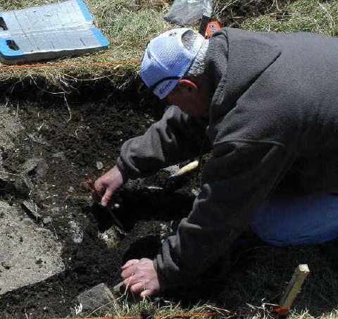 | |
| Entry: May 29, 2007 Bases of two German Stoneware Bellarmine Bottles Found at Hant’s Harbour Field work this year started on May 22. After two days repairing the fence and planting trees at Russell’s Point, we spent a day (May 24) conducting excavations at Custer’s Head in Hant’s Harbour. At Custer’s Head last November we uncovered a section of stone footing that appears to be part of the western wall of a building dating to the late 17th or early 18th century. On May 24 we established a 1m x 1m unit three metres east of our 2006 excavation in an attempt to find some trace of the eastern wall. Although we did uncover more stones in this area, the artifacts recovered from directly above them indicate that they were probably placed there in the 19th century. If they were originally part of the earlier structure, it appears that they were reused during later construction in the 19th century. However, clear evidence of the 17th century occupation was found just below the level of these stones. Among the artifacts recovered were the bases of two German manufactured stoneware Bellarmine bottles. | |
| Date: Oct. 10th '06 | |
| Time: | |
| Title: Exposing the Stone Footing at Hant's Harbour | |
 | |
| Entry: Late 17th/Early 18th Century Structure Found at Hant’s Harbour In the fall of 2004 we spent two days surveying Hant’s Harbour and discovered an archaeological site on the neck leading out to Custer’s Head (see the entries for 10/21/2004 and 10/22/2004 below). Our survey revealed that the site had been utilized by Recent Indian people in prehistoric times and had been occupied by English fishermen during the 17th and early 18th centuries. In 2005 we returned to Custer’s Head for one day and dug three 1m x 1m units at the site. In one of these units we uncovered the edge of what appeared to be a stone footing. We returned to Custer’s Head this year on November 8. It was a cold day with a high westerly wind blowing across the neck. At first I wasn’t sure if we would last the day but we managed to get in six hours of digging. During that time we extended the 1m unit west by another metre creating a 1m x 2m trench. This trench revealed the remains of a substantial stone footing. Artifacts found around and directly above this footing indicate that it is part of a building dating to the late 17th or early 18th century. Hant’s Harbour was probably utilized by migratory fishermen throughout the 17th century but it appears that year-round settlement did not begin until around 1690. When the French raided Hant’s Harbour on February 7, 1697, they reported seeing four houses there although all the inhabitants had fled. Once the fear of French attack had subsided the harbour was quickly reoccupied. A list of inhabitants compiled in 1698 indicates that there were forty-one people living at Hant’s Harbour including four planters, one woman, seven children and 29 servants. Although it is too early to say for sure, it may be that the structure we discovered is the dwelling house of one of these four planters. It certainly looks like a substantial building. Before we reburied the footing it was photographed and its location marked on our site map. | |